Sunday, November 2, 2025
9:00 AM FOR THE INSANITY COURSE, 9:00 AM FOR ELAINE'S HALF CRAZY COURSE AND 9:00 AM FOR THE SANITY COURSE
C to C Race Directions & Important Information
Here we go again!! The Eighth Annual C to C Race departs from
Caledonia and Locust Streets in Sausalito and finishes at
Cavallo Point’s Presidio Yacht Club (thus “C to C”). This year, the Insanity, Elaine's Half Crazy and the Sanity Race/Hikes all begin at 9:00 AM. Maps of the courses are included below. For the newbies, you may want to consider coordinating with a friend so that one of you leaves a car near the finish at the Presidio Yacht Club and the other drives your group to the start at Caledonia Street in Sausalito. Alternatively, you can simply walk back to Sausalito . . . a lovely 2 mile walk along the Bay.
In the event you have a "little one": depart from Caledonia and Locust Streets in Sausalito and walk south along the waterfront until you and your little one arrive at the Presidio Yacht Club in Cavallo Point. It's only about two miles long and the views along the way are breathtaking. Departure: anytime you want.
Finally, to assist your training experiences, here is a
C to C Playlist
for your running/hiking/cycling pleasure.
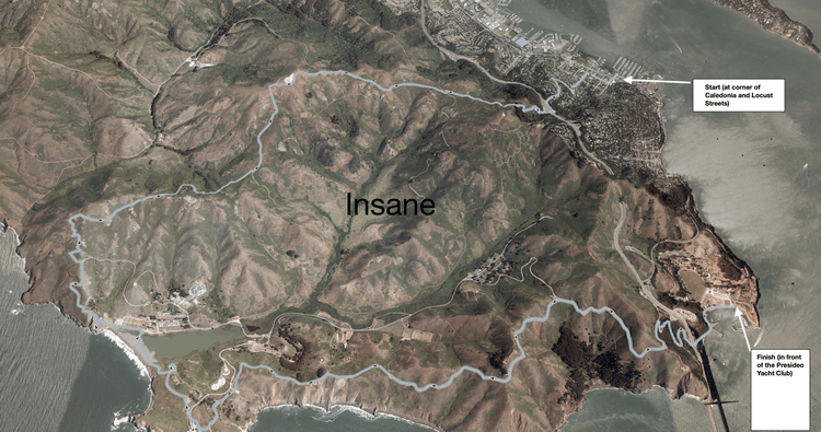
Insanity Course (13.2 miles)
The C to C Insanity Course measures approximately 13 miles from its start, at the intersection of Caledonia and Locust Streets in Sausalito, to its finish at Cavallo Point. Over the course you will climb a total of 4,000 feet, affording you fantastic views as you meander across the Marin Headlands.
The beginning of the race rises up through the winding streets of Sausalito to the Spencer Exit off Highway 101. Because this is the most confusing part of the course, we will mark it with Red and Blue plastic markers at each intersecting street. Simply go “right on red” or “left on blue” and you are “good to go”.
Next, you will proceed under Highway 101 to the Morning Sun Trail. At the top of the trail, where it flattens out, take a quick right and then a quick left and follow the dirt road. At 1.7 to 1.8 miles from the start, you will make a quick left and hard right (don’t go straight!!). If you lift your eyes, you will see the first milestone at the top of the distant hill: a white pylon (actually, it’s an old aircraft navigation pylon surrounded by a white fence).
As you approach the pylon (at the top of the climb), you will be greeted by three trails. Take the one to the left and then make sure you keep the white fence surrounding the pylon on your right. Shortly after passing the pylon you will arrive at a dirt road. Go left (south). You will descend quickly. At about 3.5 to 3.7 miles from the start, look for a dirt trail on your right. You will be leaving the Miwok Trail and ascending the Wolf Ridge Trail which will take you up to the top of “Hill 88”. Enjoy the climb.
Once you crest Hill 88, enjoy the view and take a right on the paved road, descend to Rodeo Beach and head for Point Bonita. There are a million ways to navigate the descent. Just pick one . . . you can’t go wrong. As you approach the Point Bonita Lighthouse, you will descend rather quickly and enter a tunnel which takes you to a bridge out to the lighthouse. Touch the bridge (you are on the “honor system”), turn around and head back. Enjoy the views!
With about 9 miles behind you, it’s time for another uphill slog. At the intersection of Rathbone & Conzelman Roads, proceed up Conzelman. It’s a one-way road heading towards you with two “Do Not Enter” signs facing you. Ignore them and proceed, but watch out for descending cars. At about 1.5 miles from the intersection you will see a set of stairs on the left hand side of the road. Climb them. At the top, you will proceed through a series of tunnels from which you will exit to a gorgeous view of our San Francisco Bay.
Only three miles to go and it’s all downhill!!! 1 1/2 miles into your descent, take the trail on the right (marked by a red marker). Follow the trail, down to a paved road and take a right, which will wind down under the GG Bridge. The finish line and some well-deserved cold beverages await you at the Presidio Yacht Club. Congratulations!
Arrive at the starting line 30 minutes before you depart. Leave time to park your car. Please try to assemble for a group photo just before the start. Try to coordinate with your teammates to leave one car at Cavallo Point and another in Sausalito.
- Bring a copy of these instructions with you. Forget them at your peril.
- Bring a credit card for the food and beverages.
- IMPORTANT: Bring your own water and sustenance (food, salt tablets etc.) to manage the effort. You’ll be glad you did. Restrooms can be found at Rodeo Beach or anywhere along the trail.
Elaine's Half Crazy Course (7.5 miles)
The C to C Elaine's Half Crazy Course measures approximately 7.5 miles from its start, at the intersection of Caledonia and Locust Streets in Sausalito, to its finish at Cavallo Point. Over the course, you will climb a total of 1,300 feet.
The beginning of the race rises up through the winding streets of Sausalito to the Spencer Exit off Highway 101. Because this is the most confusing part of the course, we will mark it with Red and Blue plastic markers at each intersecting street. Simply go “right on red” or “left on blue” and you are “good to go”.
Next, you will proceed under Highway 101 to the Morning Sun Trail. At the top of the trail (where it flattens out), the Insanity Course and Elaine’s Half Crazy Course depart from one another. For Elaine’s Half Crazy Course, go left and continue about .2 miles along a dirt road. You will pass through a gate onto a paved road (Wolfback Ridge Trail) that heads south slightly uphill (about 50 feet). Take a right, onto a dirt path, and follow the sign straight straight ahead to the Upper Rodeo Valley Trail which will descend gradually into the Valley.
At 3.46 miles take a left on Smith Trail. You are headed towards Julian Trail. After a few hundred feet, you will take another left onto a paved road. At this point, a few hundred feet off to your right, a bathroom is available if desired. Proceed along the paved road until at 3.73 miles go right onto a dirt road labeled Julian Trail. The views off to your left are fantastic as you head up the hill.
At 5.28 miles, you will arrive at a paved traffic circle. Head downhill. With only 2.2 miles to go, you will fly. Take your first right onto the Coastal Trail (marked by a red marker). Follow the trail, down to a paved road and take a right, which will wind down under the GG Bridge. The finish line and some well-deserved cold beverages await you at the Presidio Yacht Club. Congratulations!
Arrive at the starting line 30 minutes before you depart. Leave time to park your car. Please try to assemble for a group photo just before the start. Try to coordinate with your teammates to leave one car at Cavallo Point and another in Sausalito.
- Bring a copy of these instructions with you. Forget them at your peril.
- Bring a credit card for the food and beverages.
- IMPORTANT: Bring your own water and sustenance (food, salt tablets etc.) to manage the effort. You’ll be glad you did.
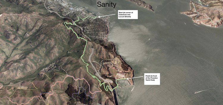
Sanity Course (4.8 miles)
The C to C Sanity course measures approximately 5 miles from its start, at the intersection of Caledonia and Locust Streets in Sausalito, to its finish at Cavallo Point. Over the course you will climb a total of 950 feet, affording you fantastic views as you meander across the Marin Headlands.
The beginning of the race rises up through the winding streets of Sausalito to the Spencer Exit off Highway 101. Because this is the most confusing part of the course, we will mark it with Red and Blue plastic markers at each intersecting street. Simply go “right on red” or “left on blue” and you are “good to go”.
Next, you will proceed under Highway 101 to the Morning Sun Trail. At the top of the trail (where it flattens out), go left and continue about .2 miles along a dirt road. You will pass through a gate on to a paved road (Wolfback Ridge Trail) that heads south slightly uphill (about 50 feet). Take a right, onto a dirt path, and then, quickly, a left onto the SCA trail. You will gently descend approximately 1.5 miles. Enjoy the beautiful views of the Pacific (on your right) and beautiful views of the San Francisco Bay (on your left).
Take your first left and begin your descent to the finish line (only 1.5 miles to go!) You will cross the paved Conzelman Road and follow the dirt path down to the parking lot (on the northern end of the Golden Gate Bridge). Take a right on the paved road and zig zag down under the Golden Gate Bridge. Pass the fishing pier and head along the water to the finish line in front of the Presidio Yacht Club. Congratulations!!!
Arrive at the starting line 30 minutes before you depart. Leave time to park your car. Please try to assemble for a group photo just before the start. Try to coordinate with your teammates to leave one car at Cavallo Point and another in Sausalito.
- Bring a copy of these instructions with you. Forget them at your peril.
- Bring a credit card for the food and beverages.
- IMPORTANT: Bring your own water and sustenance (food, salt tablets etc.) to manage the effort. You’ll be glad you did.


